It was really hard coming up with a title for today’s ride, since we really didn’t have a destination, but I had planned it for heading further inland from Lake MI to start and then eventually heading over to it for later in the day when the temps were supposed ramp up because it would be much cooler over here at that time. I could have also named it Ledge Run as well, since the first half of it was mostly all along it east of Bago and up towards the Town of Ledgeview, with lots of roads named Ledge something or another.
Anyway, I had planned out this route over the past few days for Kevin to add to his GPS, with a whole bunch of roads neither of us have probably been on before, and I love that!
We were supposed to meet around 10ish at the former Baker’s Cheese. I took Cty A this time to Elkhart and then the usual roads. When I passed the entrance into the Kettles outside of Greenbush on Cty T, a bike with bright lights was approaching and almost in my lane. Awe heck, it was Kevin! I proceeded to put on my flashers and went real slow waiting for him to return, but he wasn’t coming back. So enough of that, and shortly after I got back up to speed, I could see his lights in the distance in my rear view mirrors. Apparently he was intending on making it to Greenbush to get the “G” for his group’s alphabet game.
Well, no need to stop at Baker’s now, but we went by it to get to a road I’ve always been curious about, Hillview Road, which runs between Cty T and 23 and looked like it was built up on a dike surrounded by water. However, after looking at a satellite view, it was just through a marsh, but at least not gravel. From there we took 23 to G north, and then CCC west into Mt. Calvary and W out of Calvary. There were road closed signs for W, but we carried on and I said if nothing else, we could turn around in my Cousin Steve’s driveway, and as we approached his place, he was out mowing the lawn. So, I beeped and waved. Aunt Mary had shown him a photo of my new bike, so I suspect he figured out that it was me. Turns out they had just repaved around the intersection at W and WH. From there we went through Marytown, Johnsburg and into Pipe where we fueled up.
From there we took Lakeshore Drive north and then Faro Springs Road, which was really cool… along the lake and then twisting back up the Ledge to the east. After that we got onto 55 north into Sherwood where we had originally intended to stop for lunch at Jeanne’s Bar, but we’re thinking of trying a BBQ place in Brillion instead, which was good because Jeanne’s wasn't open yet. Well, when we got to Brillion, that BBQ was just a food truck and not even open. So, we hit Rudy’s Cafe where we stopped once with Brad last year. However I noticed for sale signs on it, but the open light was on. Turns out the owner, some lady and not Rudy, will be retiring in 14 days.
From there we headed north / northeast on a bunch of really cool roads along the ledge with spectacular views and at one point I mentioned you could see Ashwaubenon and Green Bay, including some factory off in the distance. The next time we seen it, I realized it was Lambeau Field. Haha! We also ran into some state troopers at intersections, one with its lights on that kind of freaked me out because we didn’t see him until right when we crested a hill near where he was parked. Well, apparently there was some type of pedal bike run or race, but we only seen a couple of participants. At another point we passed a small lake (Heidmann) with a nice spot to pull in, and so we turned around and went back to check it out and walk around. There were some really huge dragonflies there and I caught a couple in my photos. Such a beautiful day with temps so nice, a cool breeze out of the northeast and then some really cool clouds.
From there we headed more east than anything to get to Lake MI north of Trivers, and we found a road that went right to the lake with a really nice park and beach there, so we stopped again for a little bit. From there you could see the former Dominion nuclear plant to the north, and their current power plant to the south. When we left we took a road south that went right by the power plant and a road to it was blocked with concrete barriers and a flashing light. So, we weren’t too certain we might be able to get through up ahead, but it was fine. Turns out that road is one by the solar farm where I’ve wanted to take before when we stopped coming from the south, but Kevin always thought it was forbidden. Hahaha!
When we got to Trivers, we were a bit rerouted by a car show downtown, but I already checked with a friend at work to see if Memorial Drive between there and Manitowoc was back open yet and she said “yes, but only one lane.”
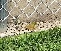
Our plan was to hit Cedar Crest plant for cream, and that is exactly what we did. While eating our cream outside we seen a frog in the parking lot hopping underneath the vehicles and thought for sure he wasn’t going to make it, but luckily it made it to the grass without getting squished.
We took Lakeshore Drive south from there and at one point we had a little rain dribble. The clouds had rolled in while we were in Mani, but we did not see any rain on the radar. Once we got onto MM west, the clouds broke and we took that to 42 south into Howards, and when I turned off of A to go home, Kevin continued on A west.
I have to say, how happy I am with my new ride and so glad I did not give up on it! I have so much more stamina on it and feel like I could ride all day, and especially on a day like today since it was such a glorious one, and with my favorite riding buddy. So grateful for days like this!!!
His map says 230 miles, but my ride was probably closer to 180.